San Ysidro is a community in the southern part of San Diego, California, located directly next to the United States-Mexico border. Although it is part of the City of San Diego, its location and relationship with neighboring communities make it feel distinct from better-known parts of the city.
For people unfamiliar with the area, one question often comes first: where exactly is San Ysidro? The answer is relatively simple. San Ysidro sits at the southernmost end of the San Diego metropolitan area, immediately north of Tijuana, Mexico.
Its position gives the community an important role in cross-border travel, shopping, transportation and commerce. It is also close to communities such as Otay Mesa, Nestor and Chula Vista.
Knowing where San Ysidro sits on the map can make it easier to plan a visit, estimate travel times and understand how the community fits into the larger San Diego area.
Location
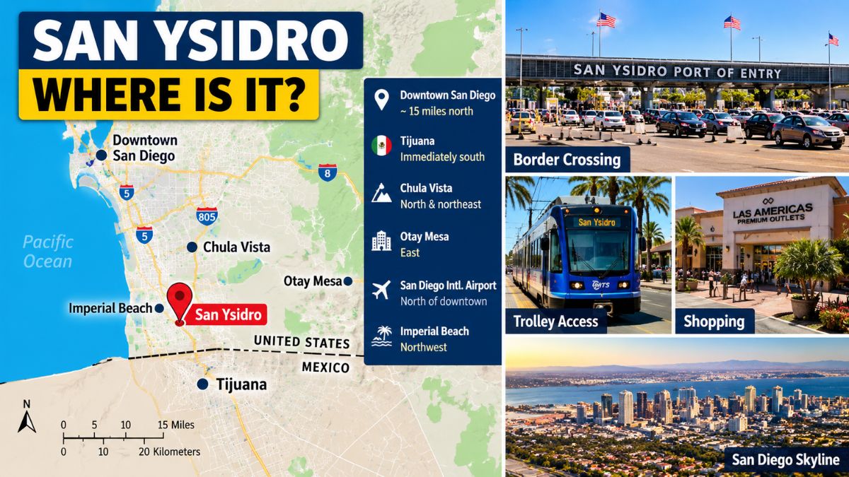
San Ysidro is in southern San Diego County, within the city limits of San Diego. It is approximately 15 miles south of downtown San Diego, although actual driving distances and times depend on the route and traffic.
The community is bounded by the international border to the south. Tijuana is immediately across the border in the Mexican state of Baja California.
To the north and northwest are other San Diego neighborhoods, while Otay Mesa is located to the east. Chula Vista is farther north and northeast.
This makes San Ysidro one of the most geographically distinctive communities in San Diego.
Border
The international border is central to San Ysidro’s identity.
The San Ysidro Port of Entry is one of the major land crossings between the United States and Mexico. It connects San Diego County with Tijuana and serves pedestrians and vehicles traveling between the two countries.
The crossing is not simply a tourist landmark. It is part of a major transportation corridor used by people commuting, visiting family, conducting business and traveling for other reasons.
Because of this, traffic conditions around San Ysidro can be different from those in other San Diego neighborhoods. Border crossing activity can affect nearby roads and travel times.
People planning to cross into Mexico should check current border information rather than relying on a fixed estimate.
Tijuana
San Ysidro’s relationship with Tijuana is one of the most important factors in understanding its location.
On a map, the two communities are extremely close. The international boundary separates them, but the distance between their urban areas is small.
Tijuana is one of Mexico’s largest cities and is part of the broader cross-border region. San Ysidro therefore sits within an area where international travel is part of everyday life.
Visitors should remember that being close to the border does not mean crossing it is automatic. Travelers need appropriate documentation and should check current requirements before attempting to enter another country.
Downtown
San Ysidro is south of downtown San Diego. The distance is manageable by car, but travel time can vary significantly depending on traffic.
Downtown San Diego contains major attractions, businesses, hotels and transportation connections. San Ysidro, by comparison, has a more neighborhood-oriented character, although its border facilities and commercial areas give it a much wider regional role.
For visitors staying in downtown San Diego, a trip to San Ysidro can be a relatively straightforward journey. However, it is better to allow additional time during busy periods.
Transit
Public transportation makes San Ysidro particularly accessible from other parts of San Diego.
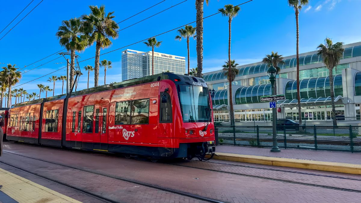
The San Ysidro Transit Center is a major transportation hub located near the international border. It connects the community with the San Diego Trolley system and other public transportation services.
The Blue Line trolley provides a direct connection between San Ysidro and destinations farther north, including downtown San Diego and other communities.
For visitors who do not have a car, this can make San Ysidro easier to reach than its southern location might suggest.
Before traveling, check the current Metropolitan Transit System schedule because routes, service frequencies and operating times can change.
Official transit information is available from the San Diego Metropolitan Transit System.
Communities
San Ysidro does not exist in isolation. It is part of a larger group of communities in southern San Diego County.
Otay Mesa is east of San Ysidro and is another important border-area community. It has its own port of entry and includes industrial, commercial and residential areas.
Chula Vista is north of San Ysidro and is one of the largest cities in the county. It offers shopping centers, parks, restaurants and other services.
Nestor and Palm City are among the nearby San Diego communities to the northwest.
Knowing these neighboring areas helps explain why a search for “San Ysidro” may sometimes produce attractions or services located just outside the community itself.
Geography
San Ysidro’s geography is shaped by its position at the southern edge of the San Diego urban area.
Unlike coastal communities such as Pacific Beach or La Jolla, San Ysidro is not primarily associated with beaches or waterfront attractions. Its importance comes largely from its border location and connections to transportation and commerce.
The area also has access to parks and open spaces, giving residents and visitors options beyond busy roads and commercial districts.
Its relatively compact geography means several local destinations can be visited in one outing, although traffic and parking can affect the practical travel time.
Shopping
San Ysidro is well known for shopping, particularly around the Las Americas Premium Outlets.
The shopping center is located near the border at 4211 Camino de la Plaza. It attracts visitors from the wider San Diego area as well as people traveling through the border region.
Its location makes it easy to combine shopping with other activities in San Ysidro.
However, visitors should not assume that every attraction described as “San Ysidro” is within walking distance of the border. Check the exact address before planning an itinerary.
History
San Ysidro’s development is closely connected to the border.
The community grew around transportation, agriculture, commerce and its proximity to Mexico. Over time, the border became an increasingly important part of local economic and social life.
Today, San Ysidro reflects a mixture of Mexican and American cultural influences. Spanish is widely used, and many local businesses serve residents and visitors from both sides of the border.
The community’s history is therefore best understood in a regional context rather than as an isolated neighborhood.
Airports
San Ysidro does not have a major commercial airport of its own.
The closest major airport serving most visitors is San Diego International Airport, located north of downtown. Travel time between the airport and San Ysidro depends heavily on traffic.
There is also a cross-border airport option in the region, the Cross Border Xpress, which provides access to Tijuana International Airport from the U.S. side through a dedicated pedestrian bridge. It is important to distinguish this facility from San Ysidro’s regular border crossing.
Travelers considering either airport should check current transportation arrangements and documentation requirements.
Distances
Exact distances depend on the starting point and destination, but these approximate relationships are useful:
| Destination | Approximate relationship to San Ysidro |
|---|---|
| Downtown San Diego | About 15 miles north |
| Tijuana | Immediately south across the border |
| Chula Vista | North and northeast |
| Otay Mesa | East |
| San Diego International Airport | North of downtown |
| Imperial Beach | Northwest |
These are general geographic references rather than guaranteed driving distances. Roads, border traffic and construction can change the time required for a journey.
Visiting
If you are visiting San Ysidro for the first time, it helps to decide whether the border itself is part of your trip.
If you simply want to explore San Ysidro, you can visit local restaurants, parks, shops and community facilities without crossing into Mexico.
If you plan to cross the border, treat that as a separate part of the itinerary. Check passport and entry requirements, transportation options and current border wait times before leaving.
The official U.S. Customs and Border Protection website provides information for travelers entering the United States.
For information about San Ysidro’s municipal services, parks and community facilities, the City of San Diego is another useful official source.
Map
On a map of San Diego County, San Ysidro is easy to identify because it sits at the extreme southern edge of the city.
Downtown San Diego is north, Chula Vista is farther north and northeast, and Tijuana lies immediately across the international boundary. Otay Mesa is to the east, while Imperial Beach is northwest.
This positioning explains much of what makes San Ysidro different from other San Diego communities. It is simultaneously a residential neighborhood, a commercial area and an important international gateway.
Travel
Travel time to San Ysidro is less predictable than the mileage might suggest.
A trip from downtown San Diego can be relatively quick when traffic is light, while congestion can make the same journey considerably longer. If you are traveling near the border crossing, allow extra time.
The same principle applies when leaving San Ysidro. If you are catching a flight or making a scheduled appointment elsewhere in San Diego, build a reasonable buffer into your plans.
Public transportation can be a useful alternative when road congestion is heavy, particularly for travelers who are comfortable using the trolley.
San Ysidro occupies a distinctive place within San Diego because of its location directly beside the U.S.-Mexico border. It is part of the City of San Diego, yet its connections with Tijuana, Chula Vista, Otay Mesa and the wider South Bay give it a broader regional role. Whether you are visiting for shopping, dining, transportation or a border crossing, understanding its location helps put the community into perspective. For the most accurate travel information, check current city, transit and border sources before setting out.
FAQs
Where is San Ysidro located?
San Ysidro is in southern San Diego beside the Mexican border.
Is San Ysidro part of San Diego?
Yes, San Ysidro is a community within the City of San Diego.
How far is San Ysidro from downtown?
It is roughly 15 miles south of downtown San Diego.
What city is across from San Ysidro?
Tijuana, Mexico, is directly across the international border.
Can I reach San Ysidro by trolley?
Yes, the San Diego Trolley’s Blue Line serves San Ysidro.